Straczynski (talk | contribs) |
Straczynski (talk | contribs) |
||
| Line 37: | Line 37: | ||
==Geography== |
==Geography== |
||
[[Image:Map Zanga.png|thumb|350px|Map of the Republic of Zanga]] |
[[Image:Map Zanga.png|thumb|350px|Map of the Republic of Zanga]] |
||
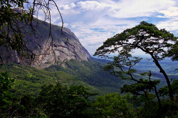
| + | [[Image:ZangaLandcape 2.jpg|thumb|350px|Typical scene in a minor tributary of the Istaar River, outside the city of Was Adaq]] |
||
| + | [[Image:ZangaLandcape 1.jpg|thumb|350px|A view of the Tsentral Plateau, near Kwaru]] |
||
Located in central [[Melania]], Zanga shares land borders with [[Istaar]], the [[Trade and Development Corporation Territory]] of [[Oteagu]], [[Afrazure]], [[Allacoa]] and [[Katikati]]. Administratively, the country is divided in seven states: [[Imeharibiwe]], [[Kijani]], [[Nulabi]], [[Uhuru]], [[Ukingo Wa Kuzini]], [[Wiketa]] and [[Zanga Sahihi]]. |
Located in central [[Melania]], Zanga shares land borders with [[Istaar]], the [[Trade and Development Corporation Territory]] of [[Oteagu]], [[Afrazure]], [[Allacoa]] and [[Katikati]]. Administratively, the country is divided in seven states: [[Imeharibiwe]], [[Kijani]], [[Nulabi]], [[Uhuru]], [[Ukingo Wa Kuzini]], [[Wiketa]] and [[Zanga Sahihi]]. |
||
Revision as of 02:35, 31 August 2020
| Jumhuriya Tzanga Republic of Zanga | |
|---|---|
| Conventional short name: | |
| Local: | Tzanga |
| Ingallish: | Zanga |
| Data codes: | ZA, ZAN |
| |
| Languages: | |
| Official: | Zangan |
| Others: | Afrazlala, Alawi, Kutu, Yare |
| Cities: | |
| Capital: | Azhyre |
| Other: | Nulabimji, Was Adaq, Kisiwa, Didiko, Sumu, Mokoka, Mhutinumbani |
| Government type: | Parliamentary republic |
| Chief Executive: | Njoma Kamendeh |
| Chief Minister: | Kimaru Mondale |
| Population: | 7.550.000 (320 est.) |
| Established: | 9th of August, 320 |
| Currency: | Fedha |
The Republic of Zanga (Afrazlala, Jamhuri ya Zanga; Zangan, Jumhuriya Tzanga; Yare, Jamhuriyar TsaSangaya) is a country in central Melania which, until August 320, formed a part of the Stervian Confederation.
Government
Uncommon for Melania, where presidential systems are the norm, Zanga is a parliamentary republic, with political power shared between a direct-elected head of state - the Chief Executive (Mikurugenzi Mkuu) - and a head of government - the Chief Minister (Waziri Mkuu) - appointed by the direct-elected National Parliament (Bungeya Kitaifa). The arrangement, a compromise brokered by the two foreign powers that liberated and occupied Zanga in mid-320 - Allacoa, with a strong presidential system and Afrazure, a constitutional monarchy - means that the Chief Minister - and, ultimately, the National Parliament - direct most daily matters of government, although most of its decisions may be vetoed by the Chief Executive - who, in turn, can only be impeached if he/she fails to survive a nationwide recall referendum called by the Parliament.
Provisionally, Zanga is led by Chief Executive Njoma Kamdendeh, formerly a professor of Economics at the University of Okocha, in Allacoa, and Chief Minister Kimaru Mondale, a veteran of the Movement for Free Zanga who has served as a spokesman for the Zangan refugees in Afrazure since 315.
General elections are expected to be held in February 321. With most political parties still pending registration, the 400 seats of the National Parliament are expected to be shared mainly between the socialist Movement for Free Zanga and other non-partisan politicians.
History
(Main article: History of Zanga)
In the 1st millenium pre-Plague times the center of the Zangan Empire, Zanga was conquered by the expanding Empire of Afrazure in 280 BP.
An important center of resistance against the colonial rule of Afrazure by the Maurestani Empire during the 2nd and 3rd centuries AP, the region was greatly affected by the Afrazurean Civil War starting in 268, as rebel groups - most notably the Movement for Free Zanga (Harakatiya Zanga Bure) - fought the Maurestani and allied Afrazurean forces. The conflict endured until 299, when Afrazure was partitioned by the international community. Zanga was annexed by the newly-independent Brolecia and reorganized as the Autonomous Region of Zanga.
During three decades of conflict, over four million inhabitants of Zanga fled their homes. During the final years of the war, many where temporarily settled in refugee camps in Allacoa, Afrazure and in Zanga itself. The high costs of maintaining the camps, as well as reconstruction efforts in the Autonomous Region, were important factors that contributed to the escalating economic crisis that led to the dissolution of Brolecia in late 301 and its replacement by the Stervian Confederation in February 302.
While the liberal government of Brolecia nominally attempted to remedy the hardships for the displaced persons in Zanga - which allowed for over three million Zangans to return to their homes - the new Sterv-dominated regime actively opposed any economical improvement on the area. The Autonomous Region of Zanga was reorganized as the Zangan Autonomous Region (ZAR) and put into constant martial law.
Zanga was one of the main fronts of the Portocapitalian-led intervention in Stervia in mid-320. The ZAR was liberated by Allacoan and Afrazurean troops and a new, independent government was organized in August.
Geography

Map of the Republic of Zanga

Typical scene in a minor tributary of the Istaar River, outside the city of Was Adaq

A view of the Tsentral Plateau, near Kwaru
Located in central Melania, Zanga shares land borders with Istaar, the Trade and Development Corporation Territory of Oteagu, Afrazure, Allacoa and Katikati. Administratively, the country is divided in seven states: Imeharibiwe, Kijani, Nulabi, Uhuru, Ukingo Wa Kuzini, Wiketa and Zanga Sahihi.
The landscape, much like in neighbouring Katikati, is dominated by the Central Melanian Plateau - however, in the southern states, the flat expanses give way to rolling plains and to the highlands of the Tsentral Plateau, which also extends into northern Allacoa. Eastern Zanga is also touched by the fringes of the Sierra Sagrada Occidental, which crosses most of Melania, from San Patricio to Kalisth'azira.
The Istaar/Estuary is the most important river of the country, serving as the border between Zanga and Katikati. The more populous cities of the country are located along its course. Other important rivers in Zanga include the Edel, the Wama and the Jima.
Rainforest cover the majority of the country, while the southern highlands are dominated by dense savannas, much like in northern Allacoa. The shores of Lake Istaar, for their part, are covered in magrove forests, subject to seasonal floodings. The region around the Istaar River has a tropical climate (Aw), with a relatively short wet season of just four months per year. Most o central Zanga, however, falls into the true tropical rainforest zone (Af), with constant rainfall throughout the year and daily temparatures normally in the range of 28°C to 35°C. The southern and eastern fringes of the country, however, feature a temperate highland tropical climate (Cwb), with milder temperatures year round.
Demographics
Zanga has roughly 7.550.000 inhabitants, according to estimates made by Allacoan, Afrazurean and Portocapitalian authorities. The most widely spoken language is Zangan, spoken as a mother tongue by close to 74% of the population, followed by the related Afrazlala language (16%), Yare (7%) Alawi (1%) and Kutu (1%). Other languages, such as Stervian and Phenixien language, make up the remaining 1%.
About 70% of the population belongs to the Zangan ethnic group - also know as Zanganese. Related Afrayenne groups include the Mandari (8%), Afrazah (6%), Alawi (1%) and Kutu (1%). Another 7% belong to the Yarene and 1% to the Kwane peoples. The remaining 6% belong to Stervian (2%), Mixtuptecan (1%), Maurestani (2%), and other Longerathian and Eras minorities (1%).
61% of the Zangans follow the Mounist faith, with most (66%) adhering to the Maurestani denominiation and a minority (30%) following the native Nijiakale tradition. The remaining 4% follow other forms of Mounism, such as Farsi, Fenizic or Sunnyah.
Cruisans make up roughly 33% of the total population, with close to 85% adhering to unorganized dioceses formerly aligned to the old Imperial Maurestani Church. Another 12% follow the Church of Altland, and 3% identify with other, mostly local denominations.
Another 6% of the population follows indigenous religions, while 1% are declared atheists or irreligious.
Refugees
Zanga was the main battleground during the final stages of the Afrazurean Civil War. Between 268 and 299, over four million people abandoned their homes due to the conflict, becoming refugees in other parts of the then-Afrazurean Empire - what later became Allacoa, Afrazure, and in Zanga itself.
In July 299, after the Partition of Afrazure, Zanga was annexed by the new Federal Republic of Brolecia. By then, the population of Zanga was only 3.100.000, with roughly 3.750.000 Zangan refugees living in Allacoa, 1.420.000 in Brolecia and 200.000 in other parts of Melania. The Brolecian and Allacoan governments undertook great efforts to transport these displaced persons back to Zanga - between 299 and 301, over 3.200.000 Zangans returned to their homeland, most using the famed Zangabus service. This trend continued, albeit at a much reduced pace, after the dissolution of Brolecia and during the first years of the Stervia - 700.000 refugees returned to Zanga between 302 and 304.
The repatriation of displaced persons essentially came to a halt after 305, when the new Zangan Autonomous Region (ZAR) was first put into martial law by the Stervian authorities. By early 319, 200.000 people, mostly ethnic Zangans, still inhabited refugee camps in the ZAR, with 35.000 more in Afrazure and close to 16.000 in Allacoa. Other 1.220.000 have declined to return and over the years acquired Allacoan or Afrazurean citizenship.