| Dola Huru la Kiso Free State of Kiso | |
|---|---|
| Conventional short name: | |
| Local: | Kiso |
| Ingallish: | Kiso |
| Data codes: | KI, KIS |

| |
| Languages: | |
| Official: | Afrazlala, Phenixien |
| Others: | Sterv, Zangan |
| Cities: | |
| Capital: | Kiso |
| Other: | Mkaidizi, Iwandi, Kikosi |
| Government type: | Unitary Republic |
| President: | Akiloye Idi-Biobaku |
| Population: | 1.075.000 (320 est.) |
| Established: | 9th of August, 320 |
| Currency: | Dhahabu |
The Free State of Kiso (Afrazlala, Dola Huru la Kiso, Phenixien, État Libre du Quiseau, Sterv, Fríríki Kiso, Zangan, Huru Nchi ya Kiso) is an independent republic in western Melania. Named after the capital and port city of Kiso, the country borders Voisionçal to the north, Katikati to the east and Allacoa to the south.
Government[]
An independent, presidential multi-party republic, Kiso ruled by a direct-elected president with five-year terms. The legislative branch is composed of a single house, the State Senate, made of 32 senators. The current president is Akiloye Idi-Biobaku, appointed by appointed by occupation authorities following the Portocapitalian-led intervention in Stervia in August 320. An economist, she is expected to retain her post following the first elections in Kiso, scheduled for June 321.
Kiso is an unitary republic, with no executive subdivisions like states or provinces. The country's municipalities do not have the power to create and pass their own legislation.
History[]
The present-day territory of Kiso shows sign of inhabitation since the 6th millennium before the Plague, although the thick jungle prevented the formation of large-scale urbanised societies for much of its earlier history. Starting circa 1.500 BP, however, the mouths of the more important rivers of the region, such as the Mkaizo and the Ki, served as the cradle for many important early states, while the interior of the country continued to host dozens of hunter-gatherer tribes.
As in neighbouring Allacoa, independent coastal city-states ruling over a number of nomadic groups and minor tribes in the surrounding rainforest were the norm, until the region was conquered by the expanding Zangan Empire in 760 BP. The Zangans founded the port city of Kiso which, together with Kisqa served as an important base for trade - and, occasionally, military - expeditions into Nuarmia. Zangan rule declined following the Zangan-Sigga Wars of 739 BP to 716 BP, which led to the formation of new powers in western Melania. As the Zangan state whitered away, the city of Kiso itself became the seat of the new Kingdom of Skruyu in 692 BP.
Sterv settlers, navigating the complicated sea route from Smalik to Svarthaedir and then to Melania, first reached the region in 550 BP and put their services as traders and navigators at the disposal of the local ruling classe. Exactly a century later, Longerathian explorers started mapping the coast and conducting trading expeditions inland. As with the rest of western Melania, Kiso was conquered between 280 BP and 270 BP by the Empire of Afrazure, which held it until the first decades after the Plague.
Afrazure lost most of its territory to the Empire of Mauritania during the Maurestani-Afrazurean war of 173 AP to 176 AP. Kiso became a part of the puppet Afrazurean regime - in practice, a colony of the Maurestani. Most of the coastal areas of Kiso were depopulated during the forced relocations of the "Trails of Blood" between 193 and 202, making room for new colonists from Eras and Logerath - majoritarily Phenixien-speaking settlers from present-day Phenixia, as well as ethnic Maurestani and Stervs.
Starting on the 230s, the hinterlands of Kiso served as important staging areas for anti-colonial groups, such as the Melanian Liberation Army, the Terrehaute Panther Movement and the Allacoan National Liberation Front. The long Afrazurean Civil War dragged intermittently until the late 290s, with the colonial regime of Afrazure falling in April 299 and Maurestania itself collapsing to local independence movements during the following month, after the Maurestani War. Maurestania proper was reorganised into three new states in June 299 - the Ordlandic Protectorate, San Patricio and the Federal Republic of Brolecia. On July, former Afrazure was partitioned between Allacoa and the Altlandic protectorate of Afrazure Altlandique, while the northern regions - including Kiso - were annexed into Brolecia as the states of Skruyu, Estuary, Flenyitty and the Autonomous Region of Zanga.
Brolecia itself collapsed between 301 and 302 due to a severe economic crisis and weak government, leading to the formation of the Listonian Free State and the People's Republic of Porto Capital, while the remainder gave way to the new Stervian Confederation in February 302. The oppressive regime of Stervia, however, led by the minority Sterv ethnic group, fell in mid-320, following a military intervention led by Porto Capital. The new, independent Free State of Kiso, centered around the important harbour of Kiso, was formed on the 9th of August 320.
Geography[]

Map of Kiso
Kiso is located in western Melania, bordering the independent states of Voisionçal, Katikati and Allacoa. The Melanian Channel, only 98 kilometres wide at its narrowest point, separates the nation from the continent of Nuarmia.
The country is marked by extensive coastal plains, gradually giving way to hills and mountains - part of the Tsatali range - on the east and northeast. The coast is covered by thin strips of mangroves and salt marshes, then broader grasslands, while the mountainous hinterlands are dominated by the high-altitude Kiso rainforest. The entire country falls into the humid tropical climate (Af) zone, with heavy rainfall throughout the year and an annual median temperature of 29,9°C.
Important rivers in Kiso include the Ki, which forms most of the border with Allacoa, and the Mkaizo.
Demographics[]
With a little over one million inhabitants, Kiso is one of the least-populated countries in Melania, just above the Duchy of Giuzza. Roughly 41% of the population is grouped under the "White Brolecian" ethnicity - that is, descendants of the Logerathian settlers who arrived in the region between 140 BP and 202 AP. Indigenous Afrayenne ethnic groups make up 54% of the total population and are further divided into Afrazahs (42%), Zangans (9%) and Yare (3%). The remaining 5% of the population belong to other groups, namely Stervs (3%), Maurestani (1%) and Mezapatani (less than 1%).
The most widely-spoken languages in Kiso are Afrazlala and Phenixien. Afrazlala is used as a mother tongue by over 49% of the population, mainly members of the Afrayenne ethnic groups, while Phenixien is spoken by 44% of the total population. The remainder of the population speak other languages, such as Zangan (3%), Sterv (2%), Yare (1%) and Mezapatani (less than 1%).
Kiso is a majority Cruisan country, with over 79% of the population following this faith - mostly (72%) adhering to local churches or unorganised dioceses formerly aligned to the Imperial Maurestani Church, with a minority (28%) following other denominations, such as the Church of Altland (25%) or the Ordlandic Church (3%). Mounism is the religion of 15% of the total population, with a majority (89%) adhering to the Maurestani sect and the remainder (11%) following the indigenous Nijiakale tradition. Other 1% of the population follows Mezapatism, 2% follows other native Melanian religions, and the remainder are self-declared atheists or irreligious.
Economy[]
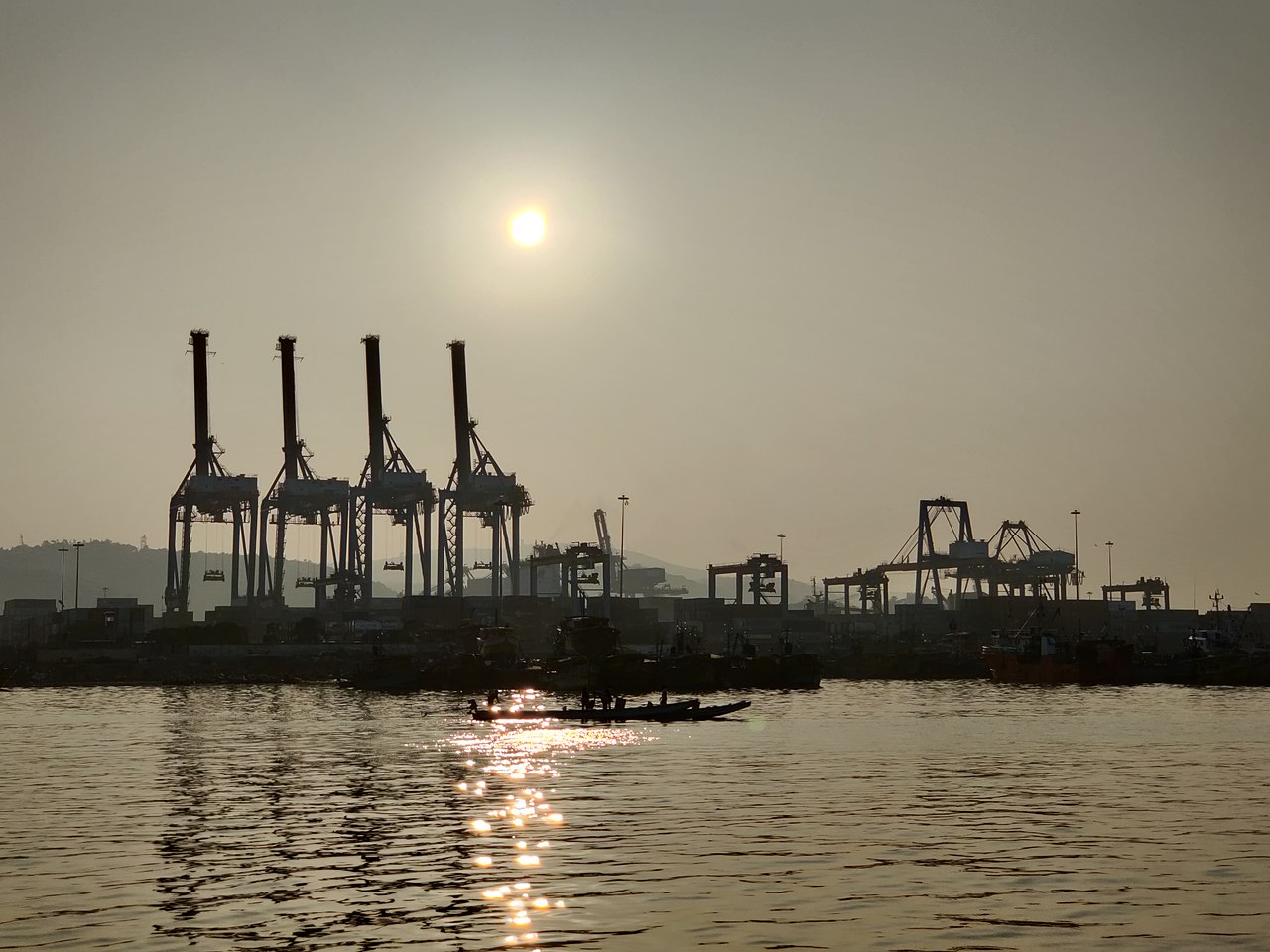
The Port of Kiso is one of the largest natural harbours in Melania
Contrasting with most other states in western Melania, the economy of Kiso is primarily focused on the services sector, in particular transportation activities. The Port of Kiso, in the nation's capital, is one of the largest natural, deep water harbours in the continent and served as the main point of exports and exports during the Stervian era. Despite the continuous decline of the Stervian economy during most of the Confederation's two decades of existence, the Port of Kiso retained its importance. Today, the port and its associated services respond for nearly one third of all jobs in the Free State of Kiso.
The services sector in the entire country answer for over 53% of Kiso's gross domestic product (GDP). Industry, encompassing sectors such manufacturing, shipbuilding and shipbreaking, food processing and textiles, is responsible for 31% of the GDP. Kiso has economically viable, although largely unexplored, reserves of nickel, iron ore, manganese and copper.
Agriculture, mostly concentrated on the coastal plains, is responsible for the remaining 16% of the GDP. Important crops include coffee, cotton, maize, sorghum, rice and tropical fruits.
The currency of Kiso is the Dhahabu (Đ).
Symbols[]

Flag of Kiso


Coat of arms of Kiso
The national flag of the Free State of Kiso is a simple horizontal bicolour of black and white, symbolising the two main ethnic groupings in the country - namely, the indigenous Melanian peoples and the immigrant "White Brolecians". The coat of arms features the same black and white colours, arranged on a wavy pattern over a white field, plus the silhouette of a modern cargo ship - a reference to the importance of the Port of Kiso to the Free State's economy.