| Jamhuri ya Katikati Republic of Katikati | |
|---|---|
| Conventional short name: | |
| Local: | Katikati |
| Ingallish: | Katikati |
| Data codes: | KT, KTK |
| |
| Languages: | |
| Official: | Zangan, Yare |
| Others: | Afrazlala, Phenixien |
| Cities: | |
| Capital: | Kawuhiani |
| Other: | Kalo, Poka, Makondo, Tzungo, Kwibeko, Nuyema, Zamunda |
| Government type: | Presidential republic |
| President: | George Bumkasse |
| Population: | 3.800.000 (320 est.) |
| Established: | 9th of August, 320 |
| Currency: | Tsuntsu |
The Republic of Katikati (Afrazlala, Jamhuri ya Katikati; Zangan, Jumhuriya Katikati; Yare, Jamhuriyar TsaKatikatiya; Phenixien, République du Katikati) is a landlocked country in Melania. Located in the central parts of the former Stervian Confederation, Katikati borders North Brolecia, Listonia, Istaar, Zanga, Allacoa, Kiso and Voisionçal.
Etimology
The name Katikati means "central" or "in the middle", in the local Afrazlala and Zangan languages. Thus, the name of the country translates literally into "Central Republic", due to its location in the centre of the former Stervia.
Government
Katikati is a democratic republic under president George Bumkasse, leader of the Liberation Council of the Central Territories (LCCT), the main group to resist the Stervian regime in the region between 302 and 320. Under its provisional constitution, proclaimed by the LCCT on the 9th of August 320, Katikati is divided in five states: Kodago, Oroene, Atete, Wakati and Kasar Filatho - those subdivisions, however, have only limited powers, as most matters are responsibility of the national government.
The country has a unicameral parliament, called the National Council - (Majalisar kasa).
The first general elections in Katikati are due to occur on the 1st of December 320. With no meaningful rival parties established above the local level, however, most analysts expect the LCCT to retain the majority of seats in the Council.
History
(Main article: History of Katikati)
Historically a patchwork of sparsely-populated statelets and tribal confederations, centered around trade routes linking important oases, the savannas of modern Katikati were conquered by the Kingdom of Istaar in 1.100 BP, before falling to the Zangan Empire in 850 BP. As the Zangan corelands fell into internal turmoil in the 690s BP, the area was granted a wide range of autonomy as semi-independent chiefdoms and provinces - although nominally still answering to the Zangan Empire.
In 555 BP, princess Gatari Wakatani, ruler of the chiefdom of Makondo, declared her realm's independence from the decaying Zangan Empire. Over the next few decades, she conquered and vassalized dozens of other states in what is now southern Katikati, establishing the Wakatani Empire in 516 BP. In the north, the Yare-speaking nomads also founded their own empire, Kasar Filatho, in 547 BP. Both Wakatani and Kasar Filatho would rule the savannas, with occasional conflicts over border areas and trade routes, until 270 BP, when the area was absorbed by the new Empire of Afrazure and made a part of the new province of Zanga.
The savannas were the first battleground of the Maurestani-Afrazurean War in August 173, when Maurestani forces advanced from Ratamahata, in what is now the northernmost part of Katikati. After facing light resistance from local militias, the main column of the Imperial Maurestani Army, comprising over fifteen thousand men, met the Afrazurean 3rd Army on the Battle of Was Widaq, on the shores of the Istaar river, from December 173 until January 174. The war, however, ended in a Maurestani victory, beginning the colonial period of Afrazure. Starting in 193, hundreds of thousands of Yare- and Zangan-speaking natives were forcebly removed from their ancestral coutnry during the so-called Trails of Blood, which cleared the fertile lands for the settlement of Liliance-speaking Maurestani and new immigrants from Eras and Longerath.
Katikati was one of the most important centers of resistance against the colonial regime. Initially unorganized and uncoordinated tribal militias, most important groups were unified into the Liberation Council of the Central Territories (Baraza Uhuru wa Wilaya ya Kati) in 210. On its peak, in 225, over 40% of Afrazure's territory was held by anti-colonial forces. A joint offensive by the Maurestani and puppet-Afrazurean forces between 230 and 235, however, crushed all significant resistance. It would take another thirty years for the reorganization of militant action against the colonial government. The Liberation Council of the Central Territories (LCCT) was refounded in 269 and joined other anti-colonial forces, such as the Movement for Free Zanga, the Afrazurean National Liberation Army and the Allacoan National Liberation Front.
The Afrazurean Civil War raged until 299, as the country severed its formal ties with Maurestania - already ravaged by the ongoing Maurestani War. Still, with most of the country in rebel hands, the international community agreed on a partition of Afrazure, with the southern corelands becoming an protectorate of Altland, Allacoa being granted independence and the northern territories - including what later became the independent nations of Katikati and Zanga - annexed by the newly-established Brolecia.
The LCCT continued its guerilla campaign against the new government of Brolecia - and, in 302, as Brolecia collapsed, the fighting continued against the new Stervian Confederation. The group was one of the main actors of the Portocapitalian intervention in Stervia, which resulted in the dissolution of Stervia and the independence of Katikati, under the rule of the LCCT, on the 9th of August 320.
Geography
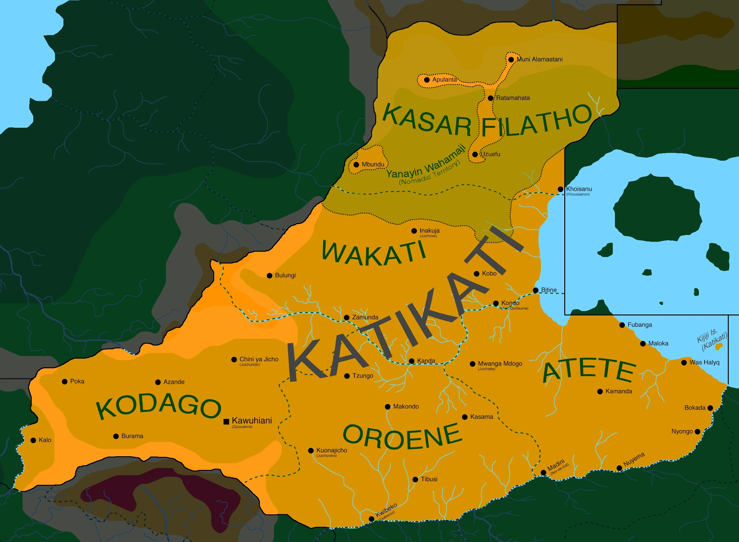
Map of the Republic of Katikati
One of only a handful of landlocked countries in Vexillium, Katikati is located in central-western Melania, bordering North Brolecia, Listonia, Istaar, Zanga, Allacoa, Kiso and Voisionçal. Administratively, the country is divided in five states: Kodago, Oroene, Atete, Wakati and Kasar Filatho.
Katikati is broadly dominated by the flat expanses of the Central Melanian Plateau. On the north, in the state of Kasar Filatho, altitudes rise quickly from 500 to over 2.000 meters, as the plains give way to the Apulanta Highlands and then, to the Alamastani Mountains in the north, straddling the borders with Voisionçal, North Brolecia and Istaar. In the west, the Terrehaute is an important mesa system, bounded from most sides by steep escarpments. The Tsatali Mountains, originating in Allacoa, also reach into southern Katikati.
Sparse savannas cover the majority of the country, becoming gradually more dense as we go south, before giving way to true rainforests in the southernmost parts of the country, in the basin of the Istaar River. The shores of Lake Istaar are dominated by grasslands and swamps, subject to seasonal floodings. Apart from the Istaar, the other main river of Katikati is the Bitine, which flows from the Terrehaute to Lake Istaar.
Most of the country has a hot semi-arid climate (BSh), with hot summers, when temperatures normally rise above 32°C, and warm to cool winters, when temperatures may fall as low as 10°C. Rains are infrequent, specially in the northern parts of the country, far from the Bitine River. Dust storms are common in Kasar Filatho. The Istaar basin, in the south of the country, offers a tropical climate (Aw), with a relatively short wet season of just four months per year.
Demographics
Katikati is home to roughly 3.800.000, according to a 320 estimative. The most widely spoken language in the country is Zangan, used by roughly 48% of the population, followed by Yare (32%), Afrazlala (17%) and Phenixien (2%). Other languages, such as Kwane, Stervian and Aro-Extreman make up the remaining 1%.
54% of the population of Katikati follows the Mounist faith, with most (72%) adhering to the Maurestani sect and a minority (27%) following the native Nijiakale (Old Path) tradition. Another 1% follows other denominations, such as Farsi, Fenizic or Sunnyah Mounism.
Other 27% are Cruisans, mostly (81%) adhering to local, unorganized dioceses formerly aligned to the old Imperial Maurestani Church. Another 16% follows the Church of Altland, present since the 250s on the territories of the former Empire of Afrazure.
Another 17% of the population follows indigenous religions, while 2% are declared atheists or irreligious.