Straczynski (talk | contribs) No edit summary |
Straczynski (talk | contribs) |
||
| Line 40: | Line 40: | ||
==Geography== |
==Geography== |
||
| − | [[Image:Map Katikati.png|thumb|350px|Map of the Republic of Katikati]] |
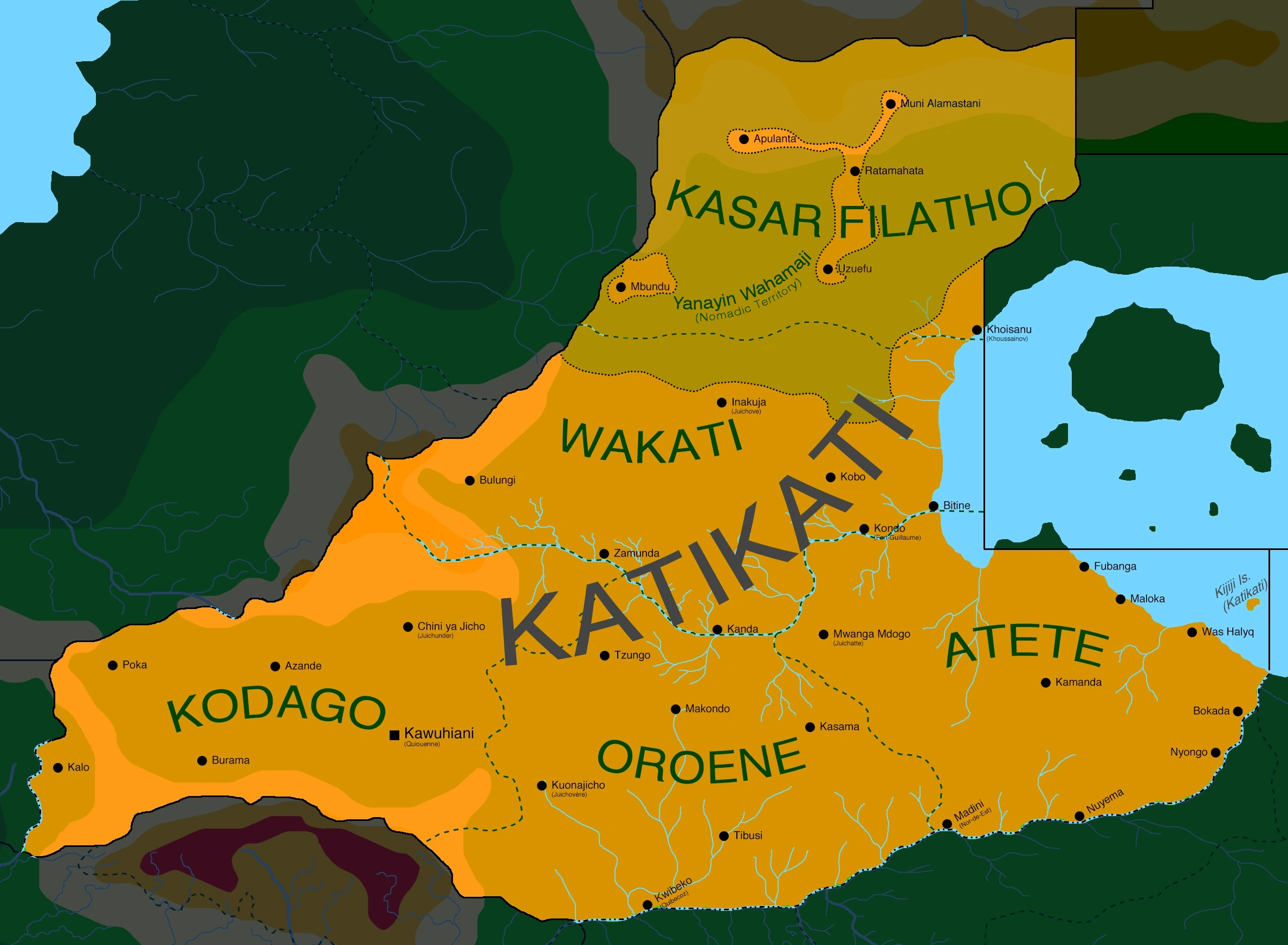
+ | [[Image:Map Katikati.png|thumb|350px|Map of the Republic of Katikati, displaying the main cities, the five states and the ''Yanayin Wahamaji'' territory]] |
| − | One of only a handful of landlocked countries in [[Vexillium]], Katikati is located in central-western [[Melania]], bordering [[North Brolecia]], [[Listonia]], [[Istaar]], [[Zanga]], [[Allacoa]], [[Kiso]] and [[Voisionçal]]. Administratively, the country is divided in five states: [[Kodago]], [[Oroene]], [[Atete]], [[Wakati]] and [[Kasar Filatho]]. |
+ | One of only a handful of landlocked countries in [[Vexillium]], Katikati is located in central-western [[Melania]], bordering [[North Brolecia]], [[Listonia]], [[Istaar]], [[Zanga]], [[Allacoa]], [[Kiso]] and [[Voisionçal]]. Administratively, the country is divided in five states: [[Kodago]], [[Oroene]], [[Atete]], [[Wakati]] and [[Kasar Filatho]]. ''[[Yanayin Wahamaji]]'', the special Nomadic Territory, comprises parts of both Wakati and Kasar Filatho |
Katikati is broadly dominated by the flat expanses of the [[Central Melanian Plateau]]. On the north, in the state of Kasar Filatho, altitudes rise quickly from 500 to over 2.000 meters, as the plains give way to the Apulanta Highlands and then, to the Alamastani Mountains in the north, straddling the borders with Voisionçal, North Brolecia and Istaar. In the west, the [[Terrehaute Plateau|Terrehaute]] is an important mesa system, bounded from most sides by steep escarpments. The [[Tsatali Mountains]], originating in [[Allacoa]], also reach into southern Katikati. |
Katikati is broadly dominated by the flat expanses of the [[Central Melanian Plateau]]. On the north, in the state of Kasar Filatho, altitudes rise quickly from 500 to over 2.000 meters, as the plains give way to the Apulanta Highlands and then, to the Alamastani Mountains in the north, straddling the borders with Voisionçal, North Brolecia and Istaar. In the west, the [[Terrehaute Plateau|Terrehaute]] is an important mesa system, bounded from most sides by steep escarpments. The [[Tsatali Mountains]], originating in [[Allacoa]], also reach into southern Katikati. |
||
Revision as of 01:59, 23 August 2020
| Jamhuri ya Katikati Republic of Katikati | |
|---|---|
| Conventional short name: | |
| Local: | Katikati |
| Ingallish: | Katikati |
| Data codes: | KT, KTK |
| |
| Languages: | |
| Official: | Zangan, Yare |
| Others: | Afrazlala, Phenixien |
| Cities: | |
| Capital: | Kawuhiani |
| Other: | Kalo, Poka, Makondo, Tzungo, Kwibeko, Nuyema, Zamunda |
| Government type: | Presidential republic |
| President: | George Bumkasse |
| Population: | 3.800.000 (320 est.) |
| Established: | 9th of August, 320 |
| Currency: | Tsuntsu |
The Republic of Katikati (Afrazlala, Jamhuri ya Katikati; Zangan, Jumhuriya Katikati; Yare, Jamhuriyar TsaKatikatiya; Phenixien, République du Katikati) is a landlocked country in Melania. Located in the central parts of the former Stervian Confederation, Katikati borders North Brolecia, Listonia, Istaar, Zanga, Allacoa, Kiso and Voisionçal.
Etimology
The name Katikati means "central" or "in the middle", in the local Afrazlala and Zangan languages. Thus, the name of the country translates literally into "Central Republic", due to its location in (roughly) the centre of Melania.
Government
Katikati is a democratic republic under president George Bumkasse, leader of the Liberation Council of the Central Territories (LCCT), the main group to resist the Stervian regime in the region between 302 and 320. The country has a unicameral parliament, called the National Council - (Majalisar kasa).
The first general elections in Katikati are due to occur on the 1st of December 320. With no meaningful rival parties established above the local level, however, most analysts expect the LCCT to retain the majority of seats in the Council.
Under its provisional constitution, proclaimed by the LCCT on the 9th of August 320, Katikati is divided in five states: Kodago, Oroene, Atete, Wakati and Kasar Filatho - those subdivisions, however, have only limited powers, as most matters are under the responsibility of the national government. The northern third of Wakati and roughly 85% of the territory of Kasar Filhato also comprise the Yanayin Wahamaji - the Nomadic Territory, where special legal exceptions apply to certain non-settled pastoral tribes.
History
(Main article: History of Katikati)
Historically a patchwork of sparsely-populated statelets and tribal confederations, centered around trade routes linking important oases, the savannas of modern Katikati were conquered by the Kingdom of Istaar in 1.100 BP, before falling to the Zangan Empire in 850 BP. As the Zangan corelands fell into internal turmoil in the 690s BP, the area was granted a wide range of autonomy as semi-independent chiefdoms and provinces - although nominally still answering to the Zangan Empire.
In 555 BP, princess Gatari Wakatani, ruler of the chiefdom of Makondo, declared her realm's independence from the decaying Zangan Empire. Over the next few decades, she conquered and vassalized dozens of other states in what is now southern Katikati, establishing the Wakatani Empire in 516 BP. In the north, the Yare-speaking nomads also founded their own empire, Kasar Filatho, in 547 BP. Both Wakatani and Kasar Filatho would rule the savannas, with occasional conflicts over border areas and trade routes, until 270 BP, when the area was absorbed by the new Empire of Afrazure and made a part of the new province of Zanga.
The savannas were the first battleground of the Maurestani-Afrazurean War in August 173, when Maurestani forces advanced from Ratamahata, in what is now the northernmost part of Katikati. After facing light resistance from local militias, the main column of the Imperial Maurestani Army, comprising over fifteen thousand men, met the Afrazurean 3rd Army on the Battle of Was Widaq, on the shores of the Istaar river, from December 173 until January 174. The war, however, ended in a Maurestani victory, beginning the colonial period of Afrazure. Starting in 193, hundreds of thousands of Yare- and Zangan-speaking natives were forcebly removed from their ancestral coutnry during the so-called Trails of Blood, which cleared the fertile lands for the settlement of Liliance-speaking Maurestani and new immigrants from Eras and Longerath.
Katikati was one of the most important centers of resistance against the colonial regime. Initially unorganized and uncoordinated tribal militias, most important groups were unified into the Liberation Council of the Central Territories (Baraza Uhuru wa Wilaya ya Kati) in 210. On its peak, in 225, over 40% of Afrazure's territory was held by anti-colonial forces. A joint offensive by the Maurestani and puppet-Afrazurean forces between 230 and 235, however, crushed all significant resistance. It would take another thirty years for the reorganization of militant action against the colonial government. The Liberation Council of the Central Territories (LCCT) was refounded in 269 and joined other anti-colonial forces, such as the Movement for Free Zanga, the Afrazurean National Liberation Army and the Allacoan National Liberation Front.
The Afrazurean Civil War raged until 299, as the country severed its formal ties with Maurestania - already ravaged by the ongoing Maurestani War. Still, with most of the country in rebel hands, the international community agreed on a partition of Afrazure, with the southern corelands becoming an protectorate of Altland, Allacoa being granted independence and the northern territories - including what later became the independent nations of Katikati and Zanga - annexed by the newly-established Brolecia.
The LCCT continued its guerilla campaign against the new government of Brolecia - and, in 302, as Brolecia collapsed, the fighting continued against the new Stervian Confederation. The group was one of the main actors of the Portocapitalian intervention in Stervia, which resulted in the dissolution of Stervia and the independence of Katikati, under the rule of the LCCT, on the 9th of August 320.
Geography
Map of the Republic of Katikati, displaying the main cities, the five states and the Yanayin Wahamaji territory
One of only a handful of landlocked countries in Vexillium, Katikati is located in central-western Melania, bordering North Brolecia, Listonia, Istaar, Zanga, Allacoa, Kiso and Voisionçal. Administratively, the country is divided in five states: Kodago, Oroene, Atete, Wakati and Kasar Filatho. Yanayin Wahamaji, the special Nomadic Territory, comprises parts of both Wakati and Kasar Filatho
Katikati is broadly dominated by the flat expanses of the Central Melanian Plateau. On the north, in the state of Kasar Filatho, altitudes rise quickly from 500 to over 2.000 meters, as the plains give way to the Apulanta Highlands and then, to the Alamastani Mountains in the north, straddling the borders with Voisionçal, North Brolecia and Istaar. In the west, the Terrehaute is an important mesa system, bounded from most sides by steep escarpments. The Tsatali Mountains, originating in Allacoa, also reach into southern Katikati.
Sparse savannas cover the majority of the country, becoming gradually more dense as we go south, before giving way to true rainforests in the southernmost parts of the country, in the basin of the Istaar River. The shores of Lake Istaar are dominated by grasslands and swamps, subject to seasonal floodings. Apart from the Istaar, the other main river of Katikati is the Bitine, which flows from the Terrehaute to Lake Istaar.
Most of the country has a hot semi-arid climate (BSh), with hot summers, when temperatures normally rise above 32°C, and warm to cool winters, when temperatures may fall as low as 10°C. Rains are infrequent, specially in the northern parts of the country, far from the Bitine River. Dust storms are common in Kasar Filatho. The Istaar basin, in the south of the country, offers a tropical climate (Aw), with a relatively short wet season of just four months per year.
Demographics
Katikati is home to roughly 3.800.000 people, according to a 320 estimative. The most widely spoken language in the country is Zangan, used by roughly 48% of the population, followed by Yare (32%), Afrazlala (17%) and Phenixien (2%). Other languages, such as Kwane, Stervian and Aro-Extreman make up the remaining 1%.
Katikati is home to two main ethnic groups: the Yarene and the Mandari. While historically the Yarene were mostly concentrated north of the Betine river and the Mandari to the south of it, both peoples have been living side by side across most of the country since the post-Plague era.
The Yarene are distantly related to the Kwane people of Istaar and make up roughly 39% of the population of Katikati. The Mandari, for their part, descend from earlier populations, who were culturally assimilated by the ruling Zangans of the Zangan Empire starting on the 9th century BP, and also received heavy influence from other Afrayenne ethnic groups. They comprise roughly 42% of the population of the country.
Other Afrayenne groups, such as Zangans, Kutu, Afrazahs and Alawis, comprise some 8% of the country's population. Maurestani make up 3%; Stervians, 4%; other Longerathian and Eras minorities 3%; Mixtuptecan groups 1%.
54% of the population of Katikati follows the Mounist faith, with most (72%) adhering to the Maurestani sect and a minority (27%) following the native Nijiakale (Old Path) tradition. Another 1% follows other denominations, such as Farsi, Fenizic or Sunnyah Mounism.
Other 27% are Cruisans, mostly (81%) adhering to local, unorganized dioceses formerly aligned to the old Imperial Maurestani Church. Another 16% follows the Church of Altland, present since the 250s on the territories of the former Empire of Afrazure.
Another 17% of the population follows indigenous religions, while 2% are declared atheists or irreligious.
Close to 48% of Katikati's population lives in cities, towns, villages or other urban environments. Among the 52% non-urbanized population, only 16% live in what elsewhere would be known as farming estates, ranches or other settled properties - the remaining 36% of the population lives as pastoral nomads (specially on the northern Yanayin Wahamaji) or hunter-gatherers (mostly concentrated on the southern rainforests).
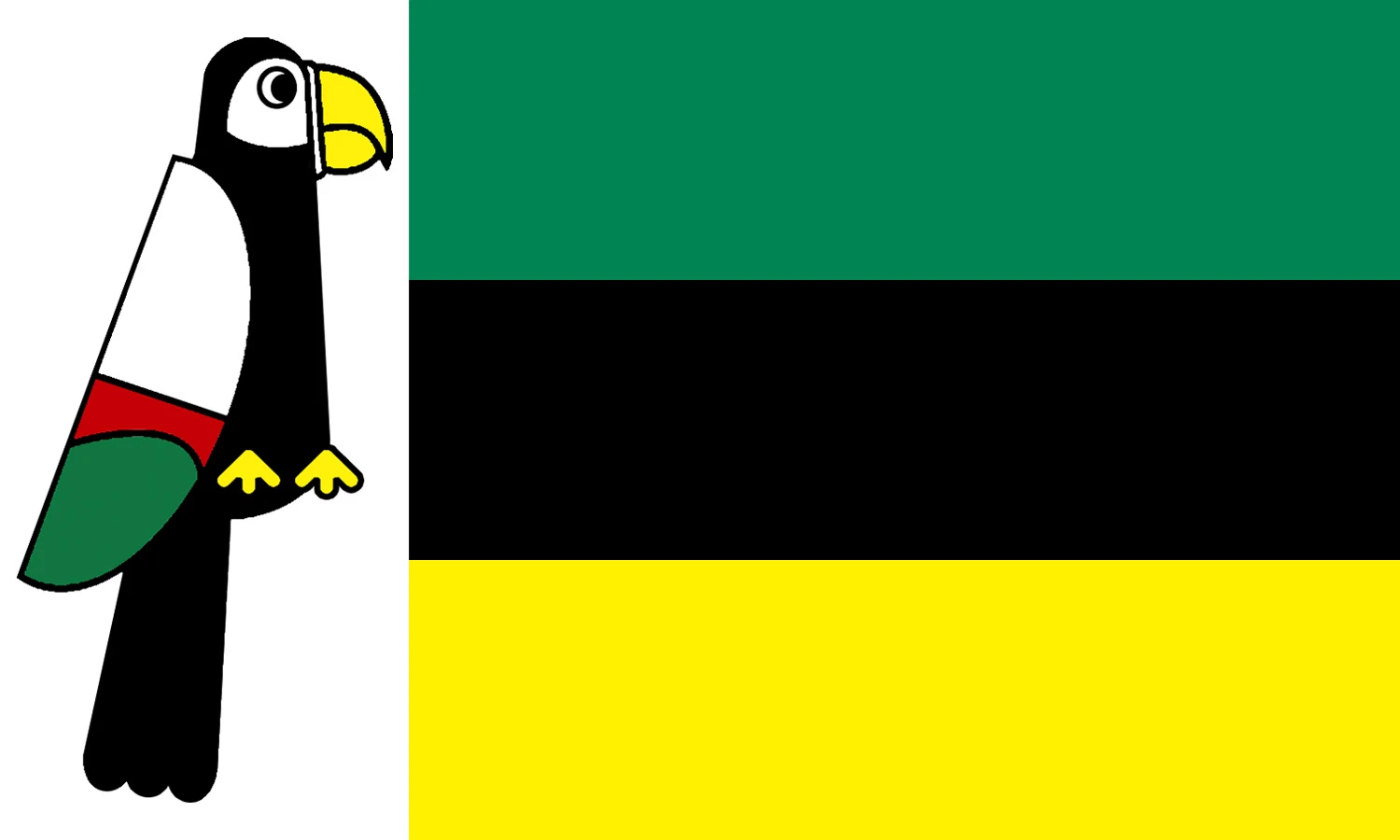
Symbols


The national bird of Katikati
(Main article: Symbols of Katikati)
The most unique symbol of the Republic of Katikati is the bird that adorns its national flag and coat of arms. An stylized form of the local Wakati Black Parrot (Coracopsis vacatiensis) was used as the emblem of the Wakatani Empire that dominated southern Katikati during the 6th century BP, while another bird, the Terrehaute White Macaw (Anodorhynchus alba) was the main symbol of the realm of Kasar Filatho, which existed around the same era. Combinations of both birds have come to symbolize the region that would later become Katikati since the 1st century BP.
The bird has no official name attached to it, but it's commonly referred to as tsuntsun mu - in Yare, our bird.
The national flag features the national bird on a white vertical bar at the hoist, combined with an horizontal tricolour of green, black and yellow - the official colours of the Liberation Council of the Central Territories, which are traditionally taken to represent the hope on a brighter future, the struggle of the Katikati people and the landscape of the country.
The national seal or coat of arms of Katikati features the bird on a round green shield, topped by five yellow stars symbolizing the five states of the Republic and, below, a yellow scroll with the name of the country.
")
")
Subnational flags
")
")
")
")
")
Military
The armed forces of Katikati, officially known as the Katikati Liberation Forces (Yare, Sojojin 'Yanci na TsaKatikatiya; Afrazlala, Jeshi la Ukombozi wa Katikati; Zangan, Jesi ya Ukombozi ya Katikati), were officially formed on the 9th of September 320, upon the dissolution of the Stervian military. Its history, however, begins in 269, with the establishment of the armed wing of the Liberation Council of the Central Territories - which, after the conclusion of the Portocapitalian intervention in Stervia in 320, became the core of the new Katikati military.
Nearly the entirety of its officer corps, as well as most conscripts, are or were members of the LCCT.
The LKF is composed of three main branches: the Katikati Liberation Ground Forces (KLGC), the Katikati Liberation Air Guard (KLAG) and the Territorial and Nomadic Guard (TNG). The LKGC is Katikati's land army, comprising one single infantry division, with a number of armoured, artillery and support battalions. The KLAG, the country's air force, operates a number of transport and combat aircraft and helicopters, mostly inherited from the old Stervian military, with a focus on counter-insurgency equipment.
The TNG is the largest of Katikati's armed branches, with over 20.000 enlisted personnel - thus absorbing the bulk of the LCCT manpower post-independence. It is tasked with the protection of government buildings, law enforcement in rural and wilderness areas, disaster relief and humanitarian aid, counter-terrorism operations as well as waterway patrols - performed via a subunit known as the Katikati Riverine Guard.
Unlike the KLGC and the KLAG, which fall under the responsibility of the Ministry of Defence, the TNG answers directly to the President of the Republic.