| Yebelayineti Ishitari Principality of Istaar | |
|---|---|
| Conventional short name: | |
| Local: | Ishitar |
| Ingallish: | Istaar |
| Data codes: | IS, IST |
| |
| Languages: | |
| Official: | Kwane |
| Others: | Yare, Zangan |
| Cities: | |
| Capital: | Maacher |
| Other: | Krassikh, Adisi Washa, Tiru Melikane, Aroge Ras, Ranwasa, Borg |
| Government type: | Constitutional monarchy |
| Ras: | Vini Salamalou |
| Prime Minister: | Aziza Makonnen |
| Population: | 2.100.000 (320 est.) |
| Established: | 9th of August, 320 |
| Currency: | Biri |
The Principality of Istaar (Kwane: Yebelayineti Ishitari), sometimes also known as the Rasinate of Istaar or the Rasdom of Istaar, is a landlocked country in Melania which, until August 320, formed part of the Stervian Confederation. The country is one of the few monarchies in the continent, ruled by Ras Vini Salamalou.
Etymology[]
Istaar, also known by the Kwane word Ishitar, is the name of two important bodies of water in Melania: Lake Istaar and River Istaar, both also known by the Phenixien name Estuary. This was the name of several historical polities of the region, most notably the pre-Plague Kingdom of Istaar from 1.200 BP to 850 BP.
Government[]
Istaar is among the few monarchies in the continent of Melania, alongside the Duchy of Joos, the Kingdom of Afrazure and the Burovian dominion of Kalisth'azira. Most daily affairs fall under the responsibility of the Prime Minister and his Royal Cabinet of Ministers, while the forty-member Royal Parliament proposes and votes new legislation - which need the approval of the Prime Minister before being put into effect. The Parliament, in turn, has the ability to impeach the Prime Minister under a simple vote of no confidence. Both the Parliament and the Prime Minister are directly-elected for six-year terms.
Although bound by a Constitution, the Ras of Istaar has considerably more powers than normally found on a traditional constitutional monarchy: instead of simply serving as a symbolic Head of State, the monarch conducts the country's foreign policy, is the commander-in-chief of the military, and has the right to dissolve Parliament and dismiss the Prime Minister.
The current provisional Prime Minister is Aziza Makonnen, a historian and wife of the last Brolecian governor of Estuary.
Istaar is an unitary state. While divided in 23 districts (weredawochi), normally named after the largest city in the area, they serve mostly to facilitate the work of the central government and do not have the prerogative to pass their own legislation.
The Ras[]
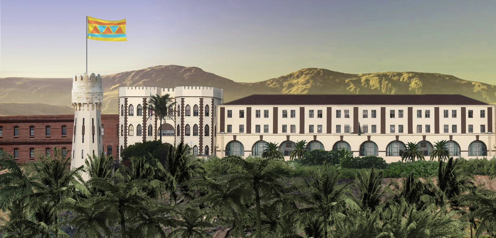
The Royal Palace of Istaar, the official residence of the ras, just outside the capital Maacher
Born in 276, Vini Salamalou is the current Ras - a Kwane word meaning leader or prince - of Istaar. While distantly related to the House of Salamalou, the ruling dinasty of the pre-Plague Kingdom of Istaar, the Ras is a closer relative of several noble families that flourished during the Afrazurean domination of the region, between 270 BP and 299 AP. After the establishment of the Stervian Confederation in 302 - and, with it, its repressive policies against the non-Sterv population - Ras Salamalou and his close family sought exile in Porto Capital, where he established the Royal Council of the Kwane Lands - initially a cultural circle and institute for Istaarian studies, which soon became one of the main social-democratic groups of the anti-Stervian resistance.
Following the Portocapitalian-led intervention in Stervia in 320, Ras Salamalou was appointed to lead the government of the new Kingdom of Istaar.
History[]
(Main article: History of Istaar)
Archeological findings and historical records show traces of human habitation in Istaar starting on the 10th millennium before the Plague. Organized states, however, only formed around the 4th millenium BP, as changes in local weather patterns favored the emergence of settled agricultural societies and, with that, urban centers and the creation of stratified societies. These early states mostly formed along the few major rivers of the area - with little arable land available beyond the shores of Lake Istaar, this led to the development of flood control and irrigation techniques. This meant, in turn, that the ruling classes of these states stayed in power thanks to their control over the access to fresh water.
In the islands of Lake Istaar, however, a new type of society developed during the pre-Plague era: these were smaller city-states and tribes, organized around a ruling class of boat-faring raiders and traders, who would constantly harass settlements along the shores of the lake, and sometimes endeavor raiding parties over the upper course of the Istaar River.
Occasionally, both the lacustrine and mainland-based statelets would organize into trading confederations or short-lived alliances. The first entity to encompass the entire region, however, only emerged in 1.200 BP, after the Salamalou tribe of Birenida Island conquered the neighbouring islands of the Istaar archipelago and established the Kingdom of Istaar. Over the next few decades, House Salamalou forced the mainland states into submission and, during the next century, conquered the savannas of what is now northern and central Katikati. Along the Istaar River, dozens of client states and tribes also fell under the dominance of the kingdom.
The Salamalou dinasty ruled much of the northern Istaar basin - from the Sierra Sagrada Occidental in the east to the Terrehaute Plateau on the west, bound on the north by the Apulanta Highlands and the Alamastani Mountains - until the 9th century BP, when the expanding Zangan Empire began encroaching its outer territories. The western territories fell by 850 BP, while the eastern shores of Lake Istaar held until 805 BP. The kingdom, however, survived on the islands of Lake Istaar, with its much-feared war galleys preventing any Zangan invasion.
The period between 805 BP and 200 BP is know as the "Age of the Lake Lords" (Zemene yehayiku getochi). Starting on 798 BP, several of the islands started to break from the domain of the Salamalou lords. While some of the smaller islands still recognized the rulers of Birenida as their ceremonial overlords, the more powerful tribes became completely independent by 710 BP. While the island states were involved in numerous conflicts between each other, the Lake Lords also dominated trade between the different states around Lake Istaar and the northernmost reaches of the Istaar River, such as the Zangan Empire, the Wakatani Empire and the realm of Kasar Filatho.
Internal turmoil in Zanga proper, combined with several rebellions between 700 BP and 690 BP, prompted the Zangan Empire to withdraw their troops from most of the Lake Istaar area. The many Lake Lords took the opportunity and seized most of what is now mainland Istaar and established a number of independent states that would dominate the political landscape of the region for the next five centuries, such as the Empire of Talaku Desete and the Biyu-Borg Confederation.
Istaar also fell victim to the expanding Empire of Afrazure prior to The Plague. Afrazurean troops first entered the region in 200 BP, advancing from other recently-conquered lands in present-day Katikati and Zanga. Although mainland Istaar was completely conquered by 175 BP, any Afrazurean attempted landing at the islands were, once again, swiftly repelled by the war galleys of the lake lords.
Over the next decades, a stalemate ensued, as neither the lake lords had sufficient numbers to attempt a reconquest of mainland Istaar, nor the Afrazureans had managed to seize the lake islands. The Treaty of Hingi Island, signed on 137 BP, acknowledged Afrazurean suzeiranity over the islands, while at the same time granting wide autonomy to the lake lords and their subjects. Most importantly, Istaarian shipbuilding and navigation techniques were spread across the rest of the empire, facilitating Afrazurean power projection over the extensive river systems and in the western coast of Melania.
The Afrazurean Empire from 73 BP to 123 AP was marked by severe decentralisation, as local rulers - the dams - took advantage of the weak imperial power to act with greater autonomy, essentially as regional warlords. While the old lake lords used the opportunity to increase their influence over the Istaar basin, the region also suffered from local wars over profitable trade routes as well as constant raids by Sterv slavers. By late 122 AP, most lake lords joined the rebellion of Yohannes Mawuni, who overthrew Afrazure's Bin Mounir dynasty and initiated a timid modernisation and industrialisation programme for the empire.
Istaar was among the earliest invasion routes used by Maurestani armies during the Maurestani-Afrazurean War of 173-176, which ended with the subjugation of Afrazure and the establishment of a colonial regime. While Kwane-speaking peoples were not extensively subject to the Trails of Blood that plagued the neighbouring Yare and Zangans, the region suffered greatly during the colonial period. The traditional autonomy of the local leaders was replaced by authoritarian rule by governors appointed from Oran. Hundreds of thousands of Istaarians were pressed into mining work in the Sierra Sagrada Occidental. Despite not being a center for anti-colonial agitation, Istaar also suffered the consequences of the internal conflict as over one million people fled from other areas of Afrazure from 175 to 200 AP.
The sparsely-populated region only saw significant anti-colonial activity in the 270s, as one important rebel group, the Liberation Council of the Central Territories (LCCT), established several bases in the Jima River valley, while using Lake Istaar to ferry personnel and material between various rebel-held areas. One of the main propaganda tools of the anti-colonial fighters, Radio Free Melania, had its main studios and transmitter installed in Kukiopi Island in 277.
The Afrazurean Civil War extended until 299, pitting anti-colonial fighters against the Afrazurean government and their Maurestani overlords. Afrazure severed its last formal ties with Maurestania in April 299. As Maurestania collapsed in the aftermath of the Maurestani War, the United Nations of Vexillium intervened and sanctioned the partition of Afrazure on the 5th of July 299. The Kwane lands were incorporated by the new republic of Brolecia as part of the provinces of Estuary and Flenyitty.
The LCCT and other minor rebel groups, however, decided to continue their guerrilla campaign against the new Brolecian government - and, in early 302, as Brolecia collapsed, the fighting continued against the new Stervian Confederation. The anti-native policies of the new Sterv-dominated regime prompted an exile of hundreds of thousands of Kwane-speaking civilians to other countries in Melania, mainly Porto Capital and Allacoa.
The Kwane lands saw the first movements of ethnic unrest in Stervia in 320, which served to mobilize several resistance movements against Sterv-minority rule. Following a Portocapitalian-led intervention in Stervia, Istaar was granted independence on the 9th of August.
Geography[]
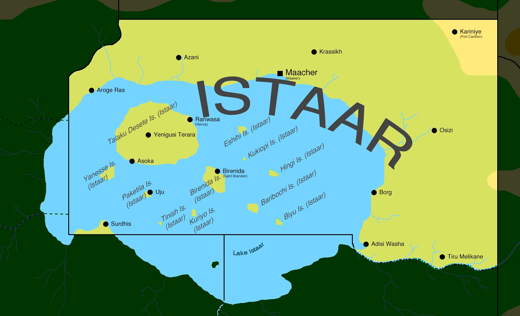
Map of Istaar, displaying the main cities of the principality
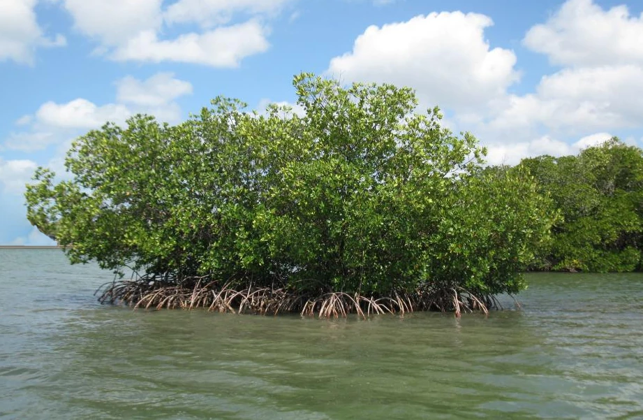

A small, typical island in Lake Istaar, just outside Adisi Washa
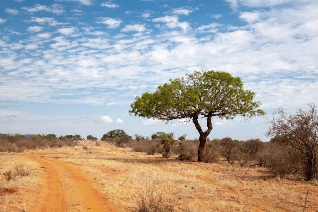
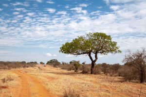
Common savannah landscape in mainland Istaar
Istaar is located in central Melania, bordering San Patricio, the Listonian Free State, Katikati, Zanga and the Trade and Development Corporation Territory at Oteagu. With only 2,1 million inhabitants, it is one of the least populated countries on Vexillium.
According to most mainstream geographers and geologists, the landscape of Istaar can be divided in two main areas: one is mainland Istaar, dominated by the flat savannahs of the Central Melanian Plateau and by several intermittent, seasonal rivers. In the far east of the country, altitudes rise quickly from 500 to 1.000 meters, as the plains give way to the westernmost fringes of the Sierra Sagrada Occidental.
The second main area of the country is known as lacustrine Istaar, dominated by Lake Istaar and its several hundred islands, ranging in size from barren, nameless rocks just a few meters long to Talaku Desete island, measuring 115 kilometres from east to west. Lake Istaar is replenished mainly by seepage from underground aquifers, as well as melted snow brought from the Sierra Sagrada Occidental by the Jima river, which forms the border between Istaar and Zanga.
Although most of the country is covered in sparse savannahs, the islands of Lake Istaar, as well as most sections of the shore, are covered in grasslands and swamps, subject to seasonal floodings.
Mainland Istaar has a climate similar to neighbouring Katikati, presenting hot semi-arid weather (BSh) with hot summers, when temperatures normally rise above 32°C, and warm to cool winters, when temperatures may fall as low as 10°C. Lacustrine Istaar, as well as the regions immediately surrounding the Jima river, offers a tropical climate (Aw), with a relatively short wet season of just four months per year.
Demographics[]
With only 2,1 million inhabitants, Istaar is one of the least populated countries on Vexillium. The most widely-spoken language in the country is Kwane, used as a first language by 81% of the population, followed by Yare (7%), Zangan (6%) and Afrazlala (4%). Other languages, such as Stervian, Maurestani, Phenixien and Aro-Extreman make up the remaining 2%.
About 85% of the population of Istaar belongs to the Kwane ethnic group, which are then subdivided into the Mainland Kwane (69%) and the Lacustrine Kwane (31%). Despite this division, both peoples have been living side by side across most of the country since the post-Plague era.
Other important groups in Istaar include the Yarene (6%), distantly-related to the Kwane, as well as other Afrayenne groups, such as the Mandari (4%) and Zangans (2%). Other groups such as Stervs, Maurestani, Mixtuptecans and other Longerathian and Eras minorities make up the remaining 3%.
Roughly 45% of the population follows the Mounist faith, with most (70%) adhering to the Maurestani sect and a minority (27%) following the Melanian Nijiakale (Old Path) tradition. Other 3% follows other Mounist denominations, such as Farsi, Fenizic or Sunnyah Mounism.
Other 40% of Istaarians are Cruisans, mostly (79%) adhering to unorganised individual temples formerly aligned to the old Imperial Maurestani Church. Another 20% follows the Church of Altland, present since the 250s on the territories of the former Empire of Afrazure. The remaining 1% adheres to other Cruisan denominations.
Other 11% of the population follows indigenous religions, while 4% are declared atheists or irreligious.
Economy[]
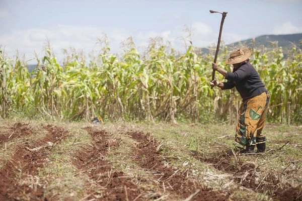

Subsistance agriculture in the Jima valley
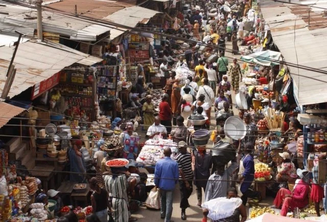

Typical market scene in the capital Maacher
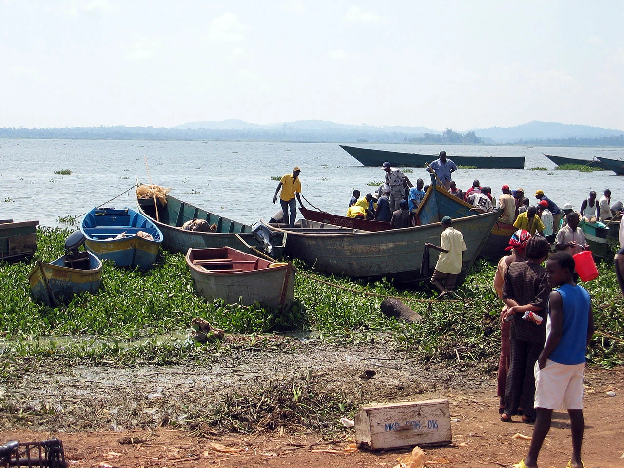
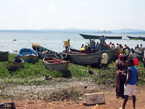
Traditional fishing boats outside Borg, on the eastern shore of Lake Istaar
(Main article: Economy of Istaar)
The economy of Istaar ranks amongst the least developed of Vexillium. Contrasting with other neighbouring countries, such as Katikati or Zanga, that suffered heavily during the post-Plague era due to colonial and post-colonial exploitation by other, more powerful states (first Maurestania and its client Afrazure, later Brolecia and Stervia), Istaar was not as extensively stripped of its natural resources - not due to any kindness by the old colonial masters, but simply because there were not any known massive deposits of usable minerals, no large rainforest to topple down, nor extensive fertile lands to be cleared of natives so more desirable immigrants could settle there.
While colonial economic exploitation was less intensively felt in Istaar, this also meant that the country has gained its independence with a negligible modern economic base. This, added to other factors such as poor infrastructure, an unskilled workforce and a limited tax base, means the principality is likely to depend heavily on foreign aid packages and investment programmes for the foreseeable future.
For most of its history, Istaar served as a source of cheap labour for neighbouring polities - by 320, foreign remittances amounted for over 32% of the country's gross domestic product (GDP).
A good part of the country's 2,1 million inhabitants engage in traditional subsistence farming - this, combined with other forms of agriculture, such as cattle herding and a small number of farms dedicated to cash crops, amount for close to 40% of Istaar's GDP. Important food crops include beans, cassava, millet, maize and several local fruits, while the most significant cash crops for exporting are cotton, jute, sisal and tobacco.
Fishing is the main industry of Istaar and alone comprises 20% of the country's GDP, as well as over 70% of the country's (legal) exports. Every day, hundreds of fishing boats, ranging from modern small trawlers to traditional reed canoes, sail the waters of Lake Istaar and the Istaar river in search of their catch. Important species harvested in Istaar include several types of catfish, tilapias, barbels and perches, as well as local species of freshwater shrimps.
Apart from fisheries, there is a small presence of other light industries in Istaar, such as sawmills, small-scale metallurgy and textiles. Forestry is also an important component of the country's economy. Mining is restricted to a few small quarries in the east of the country, producing marble, limestone and granite. Afrazurean surveys from the 280s have hinted at considerable oil and natural gas deposits in the western parts of the country, although these reserves have not yet been explored.
Other, more recent studies have also found signs of a large aquifer system over two thousand meters underneath Lake Istaar. With demand for freshwater expected to increase greatly during the near future, these deposits, if confirmed, could greatly improve the geopolitical importance of Istaar.
Traditional agriculture and fisheries may suffer over the next decades due to increased desertification and overfishing.
Energy production is heavily dependant on biomass plants for the largest cities, while smaller towns often rely on diesel generators for only a few hours every day. Even on the capital Maacher blackouts are frequent.
In order to diversify the local economy, the new government has announced plans to promote massive solar energy plants in the north of the country, as well as the construction of a few luxury resorts in Lake Istaar to boost the tourism industry.
According to foreign specialists, from 28% to 33% of Istaar's economy falls into the unregulated informal sector - that is, anything that occurs outside of any official control or taxation. This may include barter trading, the sale of locally-produced vegetables and livestock, small-scale services as well as unregistered imports and exports.
The currency of Istaar is the Biri.
Symbols[]
(Main article: Symbols of Istaar)
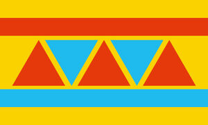
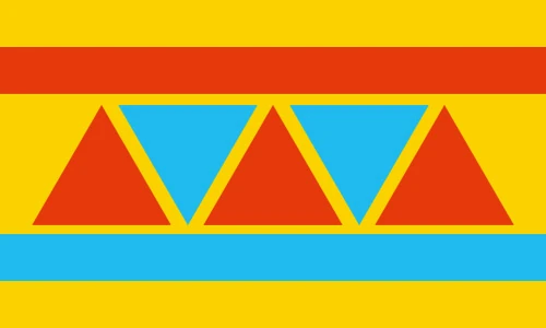
National flag of the Principality of Istaar
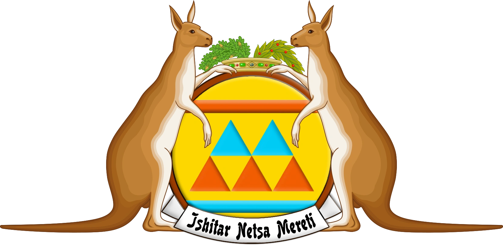
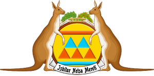
Coat of Arms of Istaar
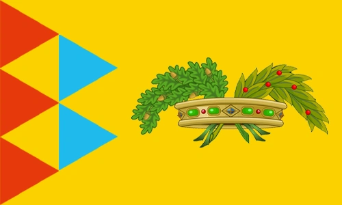

Royal standard of Istaar
Istaar's main national symbol is its national flag, composed of a golden field, two thinner orange and blue stripes, and a set of three orange and two blue triangles. The flag, designed by professor Ananin Deuah of the Department of Visual Arts of the University of Maacher, represents the landscape of Istaar: the yellow field stands for the savannahs of the country, while the blue stripe represents Lake Istaar. The orange triangles represent the islands of the lake, while he top orange stripe stands for mainland Istaar. Meanwhile the blue triangles, pointing downwards, stand for the rivers flowing into Lake Istaar - but also, symbolically, represent the integration between the mainland and lake-based parts of the country.
The entire design also evokes traditional textile patterns used by the Kwane peoples.
The coat of arms of Istaar is composed of a round shield, featuring the same elements as the national flag. The five triangles, this time, all point upwards - symbolising the unity of the people towards a brighter future. The shield is supported by a pair of Melanian kangaroos and topped by a representation of the crown of the House of Salamalou. On the bottom of the crest, a scroll with the national motto Ishitar Netsa Mereti - in Kwane, Free Land Istaar.
The royal standard of Istaar is the personal flag of the ras and features, once again, the five triangles of the national flag pointing towards the same direction, plus the crown of the House of Salamalou.